Archivo:Svjatogorsk, Lavra 3.jpg
From Wikimedia España
Jump to navigationJump to search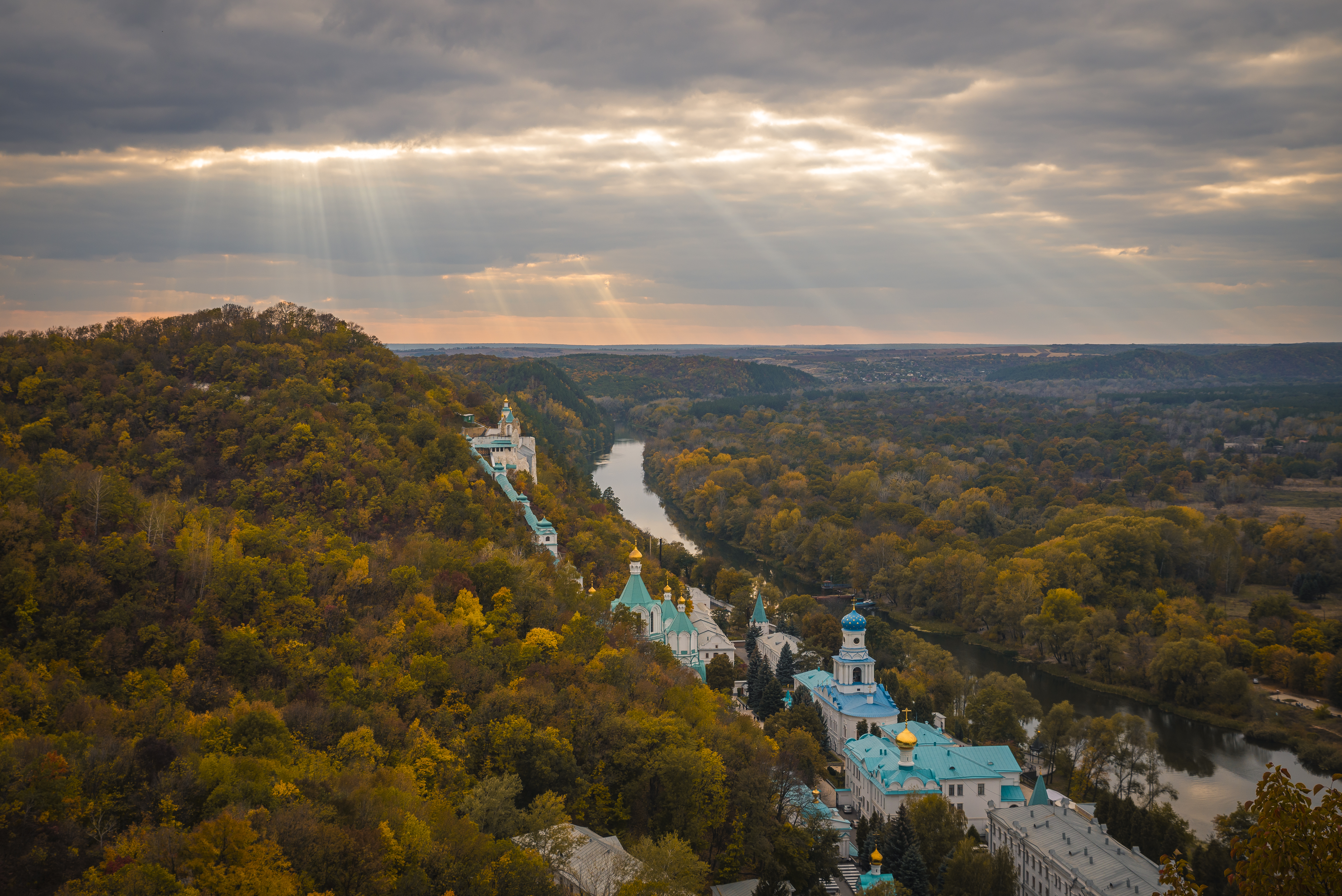
Size of this preview: 800 × 534 pixels. Other resolutions: 320 × 214 pixels | 640 × 427 pixels | 1,024 × 684 pixels | 1,280 × 854 pixels | 5,896 × 3,936 pixels.
Original file (5,896 × 3,936 pixels, file size: 16.43 MB, MIME type: image/jpeg)
Summary
| Description |
Čeština: Svjatohirská lávra, klášterní komplex ve Svjatohirsku na Ukrajině Deutsch: Das Kloster Swjatohirsk in der ukrainischen Oblast Donezk English: Holy Mountains Monastery (complex of the architecture monuments of national significance). Sviatohirsk, Donetsk Oblast, Ukraine.
Bosanski: Manastir sv. Uspenja Svjatohirsk (kompleks arhitektonskih spomenika od nacionalnog značaja). Svjatohirsk, oblast Donjeck, Ukrajina.
Čeština: Svjatogorský klášter (architektonický památník národního významu) ve městě Sviatohirsk, Doněcká oblast, Ukrajina.
English: Holy Mountains Monastery (complex of the architecture monuments of national significance). Sviatohirsk, Donetsk Oblast, Ukraine.
Español: Monasterio de las Montañas Sagradas en Sviatohirsk, Donetsk, Ucrania.
Português: Mosteiro ortodoxo cristão das Montanhas Sagradas, Sviatohirsk, região de Donetsk, Ucrânia.
Español: Laura de las Montañas Sagradas, un monasterio cristiano ortodoxo situado en Sviatohirsk, óblast de Donetsk, Ucrania Français : Laure de Sviatohirsk Polski: Ławra Świętogórska Português: Mosteiro ortodoxo cristão das Montanhas Sagradas, Sviatohirsk, região de Donetsk, Ucrânia. Русский: Святогорская лавра (комплекс памятников архитектуры национального значения № 154). Украина, Донецкая область, город Святогорск Српски / srpski: Свјатогорска Успенска лавра Українська: Святогірська лавра (комплекс пам'яток архітектури національного значення № 154). Донецька область, Святогірськ Слов'янської міськради, вул. Зарічна, 1 |
||
| Date | |||
| Source | Own work | ||
| Author | Konstantin Brizhnichenko |
| Camera location | | View this and other nearby images on: OpenStreetMap |
|---|
Assessment

|
This image was awarded with the 1st prize worldwide in Wiki Loves Monuments 2014 Other languages:
|
|
|
This image was awarded with the 3rd prize in the national contest of Ukraine in Wiki Loves Monuments 2014 Other languages:
|
|
This image was selected as picture of the day on Wikimedia Commons for 9 May 2015. It was captioned as follows: English: Holy Mountains Monastery (complex of the architecture monuments of national significance). Sviatohirsk, Donetsk Oblast, Ukraine. Other languages:
Bosanski: Manastir sv. Uspenja Svjatohirsk (kompleks arhitektonskih spomenika od nacionalnog značaja). Svjatohirsk, oblast Donjeck, Ukrajina. Čeština: Svjatogorský klášter (architektonický památník národního významu) ve městě Sviatohirsk, Doněcká oblast, Ukrajina. English: Holy Mountains Monastery (complex of the architecture monuments of national significance). Sviatohirsk, Donetsk Oblast, Ukraine. Español: Monasterio de las Montañas Sagradas en Sviatohirsk, Donetsk, Ucrania.
Sviatohirsk, Donetsk, Ucrania. Português: Mosteiro ortodoxo cristão das Montanhas Sagradas, Sviatohirsk, região de Donetsk, Ucrânia. |
Licensing
Konstantin Brizhnichenko, the copyright holder of this work, hereby publishes it under the following license:
This file is licensed under the Creative Commons Attribution-Share Alike 4.0 International license.
Attribution:
- You are free:
- to share – to copy, distribute and transmit the work
- to remix – to adapt the work
- Under the following conditions:
- attribution – You must give appropriate credit, provide a link to the license, and indicate if changes were made. You may do so in any reasonable manner, but not in any way that suggests the licensor endorses you or your use.
- share alike – If you remix, transform, or build upon the material, you must distribute your contributions under the same or compatible license as the original.

|
This image was uploaded as part of Wiki Loves Monuments 2014.
|
 |
_DSC_1062.JPG)
_DSC_9661.jpg)
.jpg)
File history
Click on a date/time to view the file as it appeared at that time.
| Date/Time | Thumbnail | Dimensions | User | Comment | |
|---|---|---|---|---|---|
| current | 01:16, 16 November 2014 | | 5,896 × 3,936 (16.43 MB) | Brizhnichenko | Більша роздільна здатність зображення |
File usage
The following page uses this file: